Bobby Anderson writes about Paletwa, in southern Chin State, in a two-part series.
This series accompanies a photo essay of Paletwa, including parts of neighboring Rakhine state. Read Part Two here.
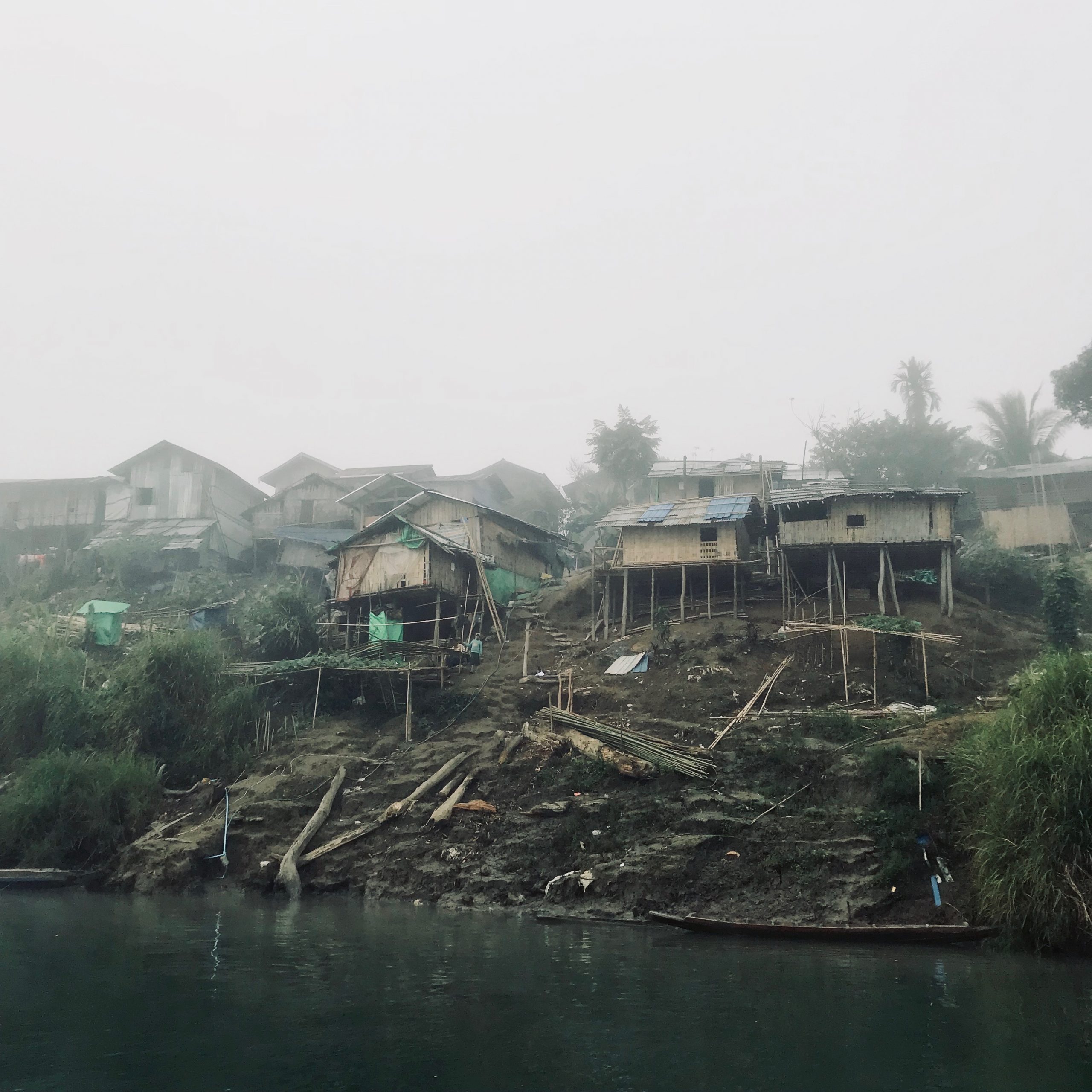
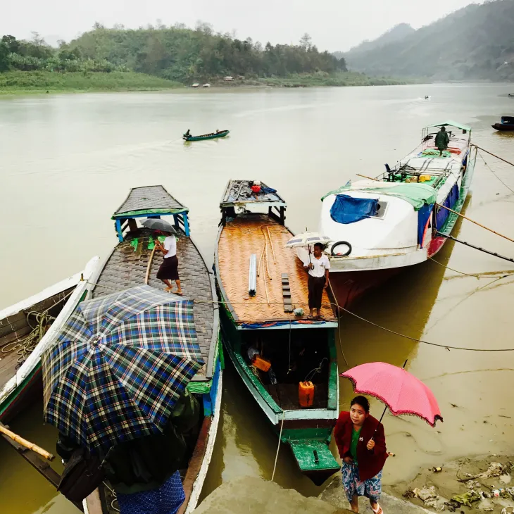
At dawn the upper reaches of the Kaladan River are blanketed with mist extending to the treetops of her banks. This is the time when cooking fires start, roosters wake, babies cry until mothers nurse, and singing bowls are lightly struck. The fog lifts as the sky lightens behind the hills to the east. Fishers emerge from and disappear into that mist in tarpaulin-covered longtail boats of darkened wood: the stuff of classical Guóhuà paintings were it not for puttering engines powering propellers mounted at the ends of long drive shafts.
I fetishize the river and those who dwell near and upon it because I am divorced from their ritual, their worry. The downsides are visible to me when a motor stalls or a drive shaft breaks upriver and we are transformed into nothing but a leaf upon the Kaladan, and its ability to destroy is conveyed, especially during the rainy season when the river displays the tendencies of some displeased deity. The Kaladan is the source of life and death; draw water from it, ambush soldiers upon it, capsize in current and become the sustenance for those who make a home in its tumult.
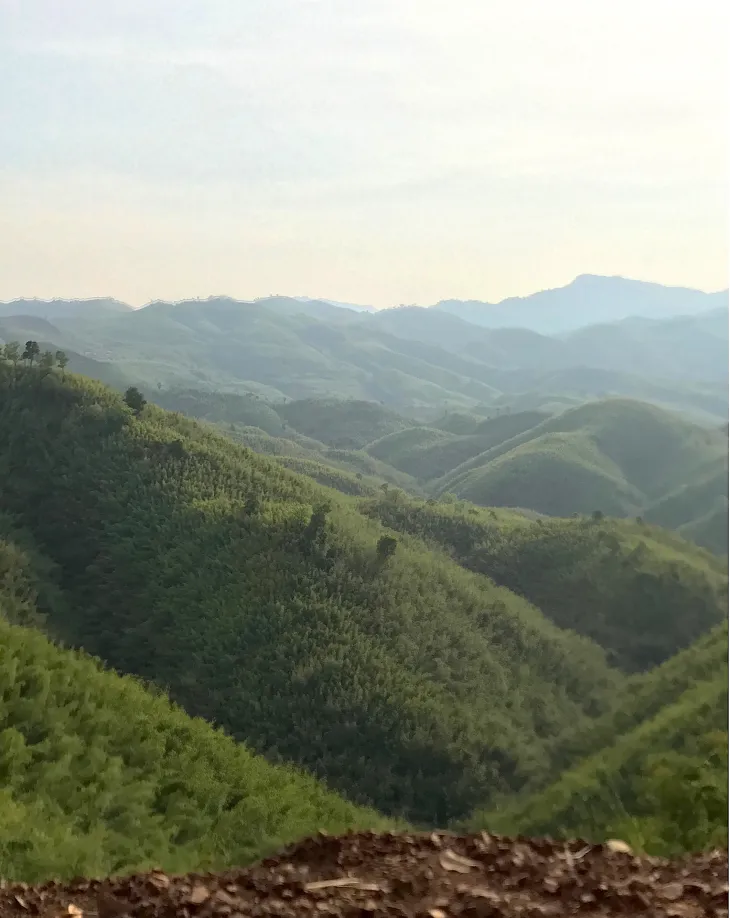
Myanmar’s Chin state is distinguished by mountain, forest and river, sparse and scattered populations, and a monsoon that cuts access from June to September. The state shares long and unmonitored borders with Bangladesh to the west and India to the north. It is the poorest state in the Union, and Paletwa is its southernmost and poorest township.
Rakhine is the lingua franca of the river, whilst Chin dialects are the reserve of the hills: most Chins speak Rakhine, for it is the language of trade, and many Chin who speak no Burmese are fluent in Rakhine. Rakhine, for their part, speak Burmese—a related language—but generally don’t speak Chin. The word for “us” in many a Chin dialect, Zomi, was adapted by Willem Van Schendel to name Zomia, the upland South – Southeast Asian land massif which stretches from Vietnam to Tibet. In the hills and further up the river, the Burmese language is rarely found, except amongst soldiers, who from the end of the Second World War until recently were a rare sight in Paletwa.
Paletwa, and the rest of Chin, has long been on the periphery of the Union, not just in geographic, but in developmental terms: in the 1960s the state didn’t possess a single secondary school, and today it has only one tertiary institute, in Hakha, which opened in 2017. In Paletwa, the little development which can be found is on the Kaladan, along with the only foreign investment: the Indian Government’s Kaladan Multi-Modal Transport (KMMT) project, which will connect that country’s Northeast to the Bay of Bengal via Sittwe and the Kaladan, with dredging in Sittwe harbor to accommodate a six meter draft, a new port facility across from Paletwa town, and a new road connecting Paletwa to Zorinpui, Mizoram state. Other than India, and the Union of Myanmar’s National Community Driven Development Project), which builds small-scale infrastructure across Paletwa, there’s little else to speak of, other than roads in Samee, and small-scale waterworks constructed by the International Rescue Committee. Paletwa town boasts of a new four-story building and a 3G telecommunications signal which disappears 15 minutes north or south of it. The town has electricity from 1800 to 2200 hrs daily, with an extra hour both morning and night in the weeks prior to student exams. Earthen roads, passable by 4×4 vehicles, connect a mud flat ten minutes southeast of Paletwa town, on the other side of the river, to Samee in the east, and Kyauktaw/ Sittwe to the south. The state government, for its part, speaks of the establishment of “special economic zones” in Paletwa, a shibboleth to attract investment. Still others say “ecotourism”. Surely others will soon say “blockchain”.
The government is generally restricted to Paletwa town, of which the General Administration Department under the military-controlled Ministry of Home Affairs is the most powerful and extensive node. The township Immigration office, under the civilian government, is also key to control: it regulates not only foreigners, but the internal immigration of Myanmar’s people, from township to township, and the fact that their paper records are eroding from silverfish, rainwater, and mold across the country, does not serve to dilute their power. This control, exercised jointly by both civilian and military arms of government, may not be apparent to foreigners who limit themselves to Yangon and select urban areas and tourist destinations where surveillance has receded. In other areas, it is palpable.
Beyond Paletwa town, however, the government shrinks to teachers, many of them on daily wages and unqualified, and the GAD village tract appointees. And it is in those appointees that a nascent democracy, or at least consensus, can be discerned. Across Myanmar’s villages, households are organized into blocks of ten, the (male) heads of whom choose their own leader. Those leaders select a village head, and those village heads in turn select a village tract representative who is nearly always accepted by township GAD.
Government neglect of Paletwa, and the rest of Chin, across generations, resulted in nary a response: while the Chins were stereotyped as a “martial” people, and were eagerly recruited by the British, and later Myanmar’s armed forces or Tatmadaw, the Chins did not display this supposed talent in the form of effective insurgency in the same ferocious manner as the Union’s Kachin, Karen, and Shan. The Chin National Front, which formed in the 1960s, never waged enough of an insurgency to trigger a meaningful Tatmadaw response, such as the “four cuts” campaigns the Tatmadaw subjected the civilian “bases” of other insurgent groups to, completely depopulating the Pegu Yoma and other areas, for example. The CNF generally exists on paper now, or in the memories of veterans residing abroad. They have been described by Bertil Lintner as less an insurgency and more an NGO. With a few rifles at their disposal, they could be better characterized as a hunting club. With that in mind, any characterization of the CNF’s signing of the 2015 National Ceasefire Agreement or NCA as removing a “stumbling block” to Chin development, is laughably ignorant.
Over time, however, Union neglect, of Rakhine primarily, but also, Chin, has led to more significant consequences, from amongst elements of the Rakhine community, in the form of the Arakan Army or AA. Beginning in 2015 it began to make its presence felt in the west, firstly in Rakhine, but now more substantially in Chin- Paletwa Township in particular.
And besides being a highway, the Kaladan River is a great place to ambush soldiers.
Bobby Anderson (gletkin@gmail.com) is a Myanmar-based Research Associate at the School of Oriental and African Studies, University of London. He thanks Jasnea Sarma for her comments on an earlier draft.